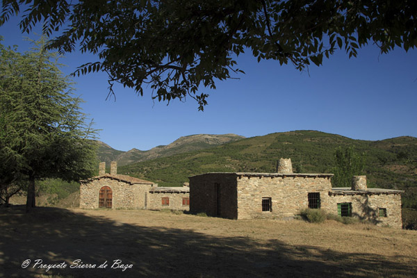
Today, I should like to talk you about the case of an abandoned village, in the province of Granada (the province with the most of the abandoned villages in Andalusia), in the Sierra of Baza, south Eastern Spain: Bastidas.

BASTIDAS is housed at 1,300 metres above sea level, in the river basin Bodurria. Inside, too, the limestone area of the Park, part of the complex called Alpujárride.
The origin of this farmstead is located in the Century XVIII, in which Don Carlos and Don Manuel de la Bastida, minor clerics who owned three farmsteads, in this river, they left their name to the population centre.
The small village is totally uninhabited, since the 60s, and, even if its rehabilitation was tried, in the early 90s, as a rural shelter, for which several houses, of rustic architecture and structure, were designed, along with a clubhouse and a chapel , using four years of work by the Floranes Workshop School, after winning the City council of Baza the transfer of the property, for 30 years, from its property, the Ministry of Environment of the Junta de Andalusia, the works were unfinished and, since seven years ago, they are totally paralyzed, in spite of all corporations of the City council of Baza currently have committed –including the current— their conclusion, with the sad fact that none of them has moved one stone and attend impassives to its destruction by time, forgetfulness and ignorance, of the work, that students of that school workshop began, with so much hope.
The natural vegetation of the area is the oak, being able to locate still outstanding feet of oak in the area, which are among the pine reforestation, invading this whole hillside. If a thinning of pines was done, it could help the natural regeneration of the oak, in these places.
In front of the farmhouse of Bastidas, and across the Stream Bodurria, are visible some impressive natural caves, like the Cave of Golfa, some dwellings, that have been occupied by humans, since 7,000 years ago and well into the last century XX, which gives a good idea of the continuity of human settlement, in the Sierra, over the centuries, taking advantage of the natural conditions, offered by the terrain.
At the bottom of the stream, which we can descend through a path, that was conditioned by the Floranes Workshop School and that can carry on us hike, about 2 hours, at Floranes, we can locate the ruins of an old water mill, it is the Mill of the wonders, that, in the National Topographic Map IGN, to 1: 25,000 scale, is mistakenly summoned to the right of the stream, downstream, when it is on the left side.
How can you go to Bastidas?. This village is accessible from the Local Road of Caniles to Escúllar, in which we will take, to the Km. 34.5, a forest track, that about 1.5 kilometres long and it will take us downstream, to the junction with a lane, from the left side, that will lead us to Bastidas. This last track is cut with a chain, so it is necessary to walk, for about 200 metres, to the village.
Well, I hope that anyday you can go to Bastidas.
Until my next post, kind regards,
Luis.
Sponsored by Costaluz Lawyers.
Please click below:
